| April
30, 03
Remotely Operated Vehicles
The remotely
operated vehicle (ROV) that we are using throughout the cruise is
the Phantom S-2,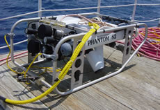 produced by Deep Ocean Engineering from San Leandro, California (Figure
at right). There are different classes of ROVs; from the small
“flying eyeballs” to the larger workhorses utilized by
the petroleum industry. The Phantom S-2 is a mid-range low cost ROV
at approximately $50,000 for the basic unit. After all the technical
equipment an upgrades are included the cost of our Superphanton is
approximately $250,000. The peripheral equipment in this case might
include, cameras, samplers and navigation systems. The Phantom S-2
is a unit that can be used for a wide variety of jobs. NOAA’s
National Undersea Research Center (NURC) from UNC-Wilmington has used
this ROV for wide range surveying in the Gulf of Mexico, site-specific
video and still image data collection, and investigation of potentially
contaminated sites. That’s right – investigation was needed
to study a toxic site under the Arctic ice. In this case the ROV was
used to explore a location potentially harmful (and certainly dangerous)
to scuba divers.
produced by Deep Ocean Engineering from San Leandro, California (Figure
at right). There are different classes of ROVs; from the small
“flying eyeballs” to the larger workhorses utilized by
the petroleum industry. The Phantom S-2 is a mid-range low cost ROV
at approximately $50,000 for the basic unit. After all the technical
equipment an upgrades are included the cost of our Superphanton is
approximately $250,000. The peripheral equipment in this case might
include, cameras, samplers and navigation systems. The Phantom S-2
is a unit that can be used for a wide variety of jobs. NOAA’s
National Undersea Research Center (NURC) from UNC-Wilmington has used
this ROV for wide range surveying in the Gulf of Mexico, site-specific
video and still image data collection, and investigation of potentially
contaminated sites. That’s right – investigation was needed
to study a toxic site under the Arctic ice. In this case the ROV was
used to explore a location potentially harmful (and certainly dangerous)
to scuba divers.
In our case
we are working with an ROV that can, if necessary be handled by a
two-man team. It 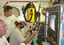 weighs
120 lbs. and is equipped with 4 thrusters each powered by a ¼
horsepower motor. The ROV runs on 110V A/C power, the same as most
electronics in an average home. This means that the ROV is easy to
power and never needs to be recharged. Unlike submersibles which normally
have a 3 or 4 hour run-time, an ROV can run indefinitely, as long
as there is a pilot above the water at the controls. The ROV is also
extremely versatile with respect to the variety of platforms from
which it can work, such as a dock, a 30 ft. boat or a large research
vessel. The ROV can also accommodate a number of surveying tools.
On our mission, we’ve mounted a digital still camera with a
3.0 mega pixel capability, a strobe, a mini-DV color video recorder,
temperature gauge and depth gauge, and a manipulator arm for acquiring
small samples. weighs
120 lbs. and is equipped with 4 thrusters each powered by a ¼
horsepower motor. The ROV runs on 110V A/C power, the same as most
electronics in an average home. This means that the ROV is easy to
power and never needs to be recharged. Unlike submersibles which normally
have a 3 or 4 hour run-time, an ROV can run indefinitely, as long
as there is a pilot above the water at the controls. The ROV is also
extremely versatile with respect to the variety of platforms from
which it can work, such as a dock, a 30 ft. boat or a large research
vessel. The ROV can also accommodate a number of surveying tools.
On our mission, we’ve mounted a digital still camera with a
3.0 mega pixel capability, a strobe, a mini-DV color video recorder,
temperature gauge and depth gauge, and a manipulator arm for acquiring
small samples.
The Phantom
S-2 ROV is made with a fiberglass body and mounted within a steel
cage for protection. Its overall size is approximately 2’ wide
x 4’ long x 1.5’ tall. If maintained properly ROVs can
last over 15 years. The NURC ROV is now 15. When the ROV is used for
research it is billed out at almost $1000 per day – this helps
to pay the technicians, maintain the ROV, and recover the initial
cost of the unit ($500,000).
Becoming an ROV technician and operator is achievable, though not
simple. It is the culmination of many hard, fun years of work, according
to Lance Horn, the ROV operator for NURC at UNC-W. Lance started his
career in the US Navy 30 years ago as an ocean mechanic. After graduating
from Florida Institute of Technology with an AS in Underwater Technologies
in 1985, he arrived at NURC, where he began his work as a hard hat
diver. He continued to gain ground with technical qualifications including
mixed gas diving, diver medical technician training, and operating
many sorts of underwater vehicles. Lance has since become one of the
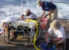
nation’s leading experts in the use of ROVs for science. (at
right: scientists repair the damaged ROV)
During each of the ROV dives we follow a pre-determined transect (a
path in a straight line) that 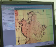 covers
areas we have designated necessary to research. These transects were
chosen based on new maps – generated on the Oculina Coral Banks
2002 mission last October – selecting areas where coral might
be found. When the ROV is lowered into the water, it is on a tether
line and cable that link the ROV to the ship, and also connect the
cameras and thrusters to the technician’s controls on deck.
When following a transect the operator must contend with current,
the ship’s speed and direction, and changing topography of the
seafloor. Some of the things the researchers are looking for using
the ROV are fish, invertebrates, coral formations and substrate (seafloor)
type. These transects are used as a sampling of what is found within
the adjacent area and for comparison with data previously collected
in the same area. (at left: computer
screen image of map track) covers
areas we have designated necessary to research. These transects were
chosen based on new maps – generated on the Oculina Coral Banks
2002 mission last October – selecting areas where coral might
be found. When the ROV is lowered into the water, it is on a tether
line and cable that link the ROV to the ship, and also connect the
cameras and thrusters to the technician’s controls on deck.
When following a transect the operator must contend with current,
the ship’s speed and direction, and changing topography of the
seafloor. Some of the things the researchers are looking for using
the ROV are fish, invertebrates, coral formations and substrate (seafloor)
type. These transects are used as a sampling of what is found within
the adjacent area and for comparison with data previously collected
in the same area. (at left: computer
screen image of map track)
|