| Charleston
Gyre |

 |
 |
 |
February 8, 2003 Drifters determine
where we go There are a variety of drifter designs, ranging from the simple to the complex. Simple drifters can be cards that are released at a known point with a return address. When the cards are found by somebody, they are returned and the release point and time and the recovery point and time provide information about ocean circulation that moved the card from release point to return point. As an aside, containers of merchandise are occasionally lost from ocean going ships. A well-publicized example is thousands of Reebok sneakers lost in the North Pacific. As the merchandise washes up on shore, information is gained about the ocean circulation from where the container was lost (release point) to where the merchandise washed up (recovery point). From this very simple drifter,
a piece of paper with a return address, a number of more complicated
designs have arisen. One of the most complicated designs has the drifter
changing its buoyancy and dropping below the surface to a certain depth,
say 500 m. On the descent, the drifter measures temperature, conductivity
and depth, among other things. In essence the drifter acts like a CTD.
Once the drifter returns to the surface, it transmits its data (temperature,
conductivity, and depth) along with its location to a land based receiving
station via satellite. This data is then combined with the data from
hundreds of other similar drifters to provide a large-scale picture
of the temperature, salinity and density in the ocean. Information about
ocean circulation is also gained from the changes in the drifter’s
position over time. These drifters can operate for months to several
years. The drifter we are following,
however, has a slight difference. In addition to everything described
above, the drifter has a GPS receiver. The Global Positional System
is made up of multiple satellites from which receivers can triangulate
their position. There is a receiver in the drifter’s globe that
determines position every 30 minutes. These positions are good to within
~ 50
|
 Drifters are oceanographic equipment and are designed to follow pieces,
or parcels, of water. The idea is that the drifter conveys information
about location at time A and at time B. The change in location (motion)
of the drifter between time A and B can then be estimated, as can the
speed (change in location divided by time). Thus, the basic purpose
of a drifter is to provide information on ocean circulation.
Drifters are oceanographic equipment and are designed to follow pieces,
or parcels, of water. The idea is that the drifter conveys information
about location at time A and at time B. The change in location (motion)
of the drifter between time A and B can then be estimated, as can the
speed (change in location divided by time). Thus, the basic purpose
of a drifter is to provide information on ocean circulation. 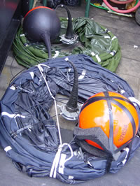
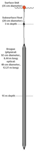
 The
drifters we are using to track the Charleston Gyre are a standard design:
WOCE-SVP. The basic premise is similar to the drifter just described,
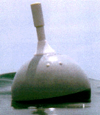
minus the change in buoyancy and CTD profiling. The drifter consists
of three parts. The globe is at the surface and contains the instrumentation,
in our case a surface temperature probe. The drogue is what ‘catches’
the water and causes the drifter to follow the parcel of water. The
drogues we are using are about 5 m long and centered at 15 m. The idea
is that the drifter is following a parcel of water at 15 m. The tether
connects the globe to the drogue and is a thin but strong wire. The
globe transmits data every 90 seconds. Satellites receive this data
and calculate a position. The position and data are then relayed to
a land-receiving station where the data is emailed to us on the ship,
as well as stored to be sent back to the laboratory at the end of the
cruise. We receive these locations every 3-5 hours and they are 3-5
hours old when we receive them. Most of the drifters we have released
are this type.
The
drifters we are using to track the Charleston Gyre are a standard design:
WOCE-SVP. The basic premise is similar to the drifter just described,
minus the change in buoyancy and CTD profiling. The drifter consists
of three parts. The globe is at the surface and contains the instrumentation,
in our case a surface temperature probe. The drogue is what ‘catches’
the water and causes the drifter to follow the parcel of water. The
drogues we are using are about 5 m long and centered at 15 m. The idea
is that the drifter is following a parcel of water at 15 m. The tether
connects the globe to the drogue and is a thin but strong wire. The
globe transmits data every 90 seconds. Satellites receive this data
and calculate a position. The position and data are then relayed to
a land-receiving station where the data is emailed to us on the ship,
as well as stored to be sent back to the laboratory at the end of the
cruise. We receive these locations every 3-5 hours and they are 3-5
hours old when we receive them. Most of the drifters we have released
are this type.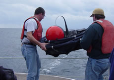 m.
The globe transmits data ever 90 sec including the GPS determined positions.
Like the other drifters, satellites receive these data and transmit
to a land-based receiving station and these are emailed to the ship
and stored for later analysis. When we receive these positions via email,
they are several hours old. We also have a receiver on the ship that
picks up the data transmission from the drifter. The receiver passes
the data to a computer where the data is decoded and the real-time position
calculated and displayed. This way we know exactly where the drifter
is and we can follow it, make MOCNESS tows and deploy the CTD.
m.
The globe transmits data ever 90 sec including the GPS determined positions.
Like the other drifters, satellites receive these data and transmit
to a land-based receiving station and these are emailed to the ship
and stored for later analysis. When we receive these positions via email,
they are several hours old. We also have a receiver on the ship that
picks up the data transmission from the drifter. The receiver passes
the data to a computer where the data is decoded and the real-time position
calculated and displayed. This way we know exactly where the drifter
is and we can follow it, make MOCNESS tows and deploy the CTD.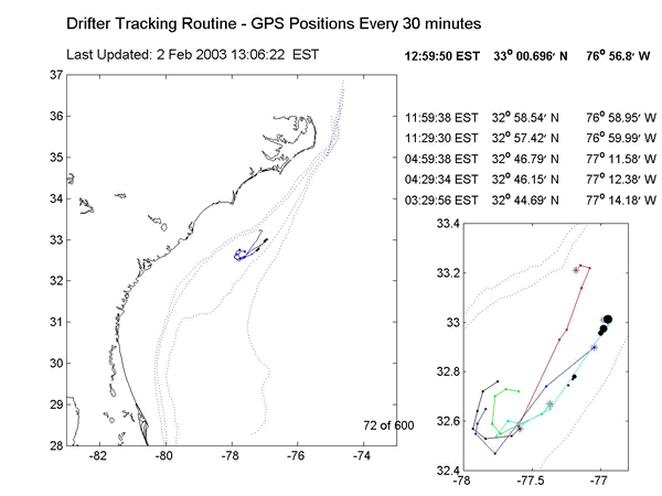
| Ph.
843-953-7263 |
Project
Oceanica Dept. of Geology & Environmental Geosciences College of Charleston Charleston, SC 29424 |
Fax
843-953-7850 |