|
 |
 |
 |
 |
Project Title:
Mapping and Characterization of the Oculina Banks Habitat Area of
Particular Concern(OHAPC) off the East Coast of Florida.
|
Ocean and Space Agencies Join
Forces to Explore Deep Coral Banks.
Wilmington, NC—Beginning October 16, days after launching the Atlantis space shuttle from Kennedy Space Center, the National Aeronautics and Space Administration (NASA) will join the National Oceanic and Atmospheric Administration (NOAA) and other ocean scientists to go in the opposite direction to study deep sea corals off Cape Canaveral, Florida. With funding support from NOAA’s National Marine Fisheries Service, the University of North Carolina at Wilmington’s National Undersea Research Center (NURC/UNCW) will lead an eight-day expedition to map the Oculina Banks marine protected area. NURC/UNCW is one of six regional centers around the nation in NOAA’s National Undersea Research Program. The NASA ship Liberty Star, managed by NASA’s Marshall Space Flight Center in Huntsville, Ala., and operated by the United Space Alliance out of Port Canaveral will support the survey. The Liberty Star is one of two ships that recover the Space Shuttle’s Solid Rocket Boosters and return them to Kennedy Space Center for refurbishment.
In the early 1980s, Harbor Branch scientists working from small submarines discovered that large areas of Oculina coral beds were destroyed, most likely by fishing trawlers. In 1984, NOAA designated over 90 square miles of the Oculina Banks as a research reserve closed to trawling. In 1994, the same area was closed to all bottom fishing, and in 2000, it was expanded to 300 square miles, now stretching 60 miles from Fort Pierce to Cape Canaveral. Rock shrimp trawlers have been caught dragging their steel doors and nets through the reserve as recently as 2001.
The National Marine Fisheries Service has set management goals for the reserve area intended to protect the reefs and restore declining reef fish populations, without ruining the net fishery. They also realize the need for increased public awareness of the reefs and problems through research, outreach, and education. According to Andrew Shepard, expedition coordinator from the Undersea Center at UNCW, “meeting the Fisheries Service’s management objectives for the Oculina reserve area requires more scientific data and information about the health of the Banks, and probable causes for the loss of coral habitat. Corals can die for a number of reasons, such as disease and temperature change. We know there is illegal fishing in the closed area, but how much does it contribute to degradation of the reefs versus other possible factors?” Complicating the problem of studying and understanding the reefs is their location under the Gulf Stream, a river in the sea that can flow four to five knots over the Oculina reserve area. “Diving is required to study most reef environments,” notes Mr. Shepard, ‘but this is no easy feat in 250 feet of water with currents that can take a diver’s mask off.” From October 16 to October 23, Seafloor Systems
Inc. from Oregon will deploy a sophisticated mapping system from the
Liberty Star to provide the first high resolution, three-dimensional
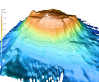
map of the Oculina Banks. The multi-beam sonar system can survey up
to 20 square miles per day at less than a meter resolution, revealing
shipwrecks and reefs never mapped or seen before. The survey results will be used to guide another expedition in the spring of 2003, when the reef fish spawn, again using NASA’s ship, plus their underwater robot and an acoustic hydrophone system for listening to fish and vessel noise. New exploration and discoveries will be guidedby the new charts.
The mission: NASA: NOAA: Liberty Star and United Space Alliance: Multi-beam sonar system: Harbor Branch Oceanographic Institution or to
contact John Reed:
|
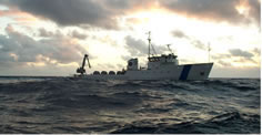 Fig.
(NASA’s Liberty Star, normally used to recover shuttle booster
rockets will conduct deep coral survey. Credit: J. Chaput).
Fig.
(NASA’s Liberty Star, normally used to recover shuttle booster
rockets will conduct deep coral survey. Credit: J. Chaput).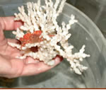
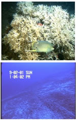 Fig.
(Healthy Oculina reef (top) and destroyed coral rubble with evidence
of trawl marks (bottom); pictures taken from Harbor Branch Oceanographic
Institution’s Clelia submersible during 2001 NOAA expedition.).
Fig.
(Healthy Oculina reef (top) and destroyed coral rubble with evidence
of trawl marks (bottom); pictures taken from Harbor Branch Oceanographic
Institution’s Clelia submersible during 2001 NOAA expedition.).