| OCULINA Coral Banks |
Daily
At Sea Log |
Oct. 19, 2002 |  |
|
 |
 |
 |
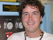
Brent Manning (pictured
below), one of our ship-mates, is a graduate student at the University
of North Carolina at Wilmington. He will receive his M.S. in Marine
Science in 2003. His expertise is in the field of Geographic Information
Systems (GIS). After we collect all of our sonar data on the Oculina
Banks, Brent will enter the information into the Oculina GIS project
and website so that it can be used worldwide by other scientists.
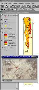
Recent innovations in GIS have
created a user-friendly environment that operates using a windows-equipped
graphical user interface. As a result of these advancements, more people
from a broad range of fields are using the technology. At present GIS
systems are used by millions of people worldwide.
Stanbury, K.B. and R.M. Starr. 1999. Applications of Geographic Information Systems (GIS) to habitat assessment and marine resource management. Oceanologica Acta, 22(6):699-703. Waltenburger, B. and M. Pickett. 1999. Integration of NOAA aerial monitoring and GIS programs for research, education, and management within the Channel Islands Marine Sanctuary. Proceedings of the 5th California Islands Symposium. Santa Barbara, CA (USA), 29 March-1 April 1999. pp. 469-471. Wright, D.J., B.T. Donahue, and D.F. Naar. in press, 2001. Seafloor mapping and GIS coordination at America’s remotest marine sanctuary (American Somoa), In Wright, D.J. (ed.), Undersea with GIS, ESRI Press, Redlands, California, 32 pp. Wright, R., S. Ray, D.R. Green, and M. Wood. 1998. Development of a GIS of the Moray Firth (Scotland, UK) and its application in environmental management (site selection for an ‘artificial reef’). The Science of Total Environment, 223:65-76.
Paul and the other engineers are
vital to the operation of the ship. The engineers oversee the maintenance
of ALL the systems aboard the ship. In case you're wondering, that includes
propulsion, air conditioning, heating, plumbing, hydraulics, refrigeration,
electrical, mechanical and more!! They have to know a lot! Paul says he loves the variety of a career at sea. He's not real crazy about the paperwork but really likes everything else. What kind of fish would Paul be? He says since he spent so many years near freshwater and fishing, he would be either a Black Bass or a Large-Mouth Bass. |
| Ph. 843-953-7263 |
Project Oceanica Lowcountry Hall of Science and Math College of Charleston Charleston, SC 29424 |
Fax 843-953-7850 |
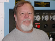 Paul Kolbe (pictured left) is the
chief engineer on the M/V Liberty Star. He owned a bait and tackle shop
on Lake Erie for many years. Since there was little to no business in
the winter, Paul would go down to the Gulf of Mexico and help out in
the engine room on various vessels. Eventually he started an apprenticeship
and with his experience and sea time, he was able to earn his license.
Paul Kolbe (pictured left) is the
chief engineer on the M/V Liberty Star. He owned a bait and tackle shop
on Lake Erie for many years. Since there was little to no business in
the winter, Paul would go down to the Gulf of Mexico and help out in
the engine room on various vessels. Eventually he started an apprenticeship
and with his experience and sea time, he was able to earn his license.