|
 |
 |
 |
|
Daily
At-Sea Logs |
| Wednesday, May 12, 2004 It is evening time again and I am nestled in my bunk reflecting on another remarkable day. The weather was perfect and the ocean was calm; however, the research did not go as smoothly as hoped. Nearly every science director has already experienced frustration at some point on this cruise, whether it be due to operation of their instruments or problems in their deployment. Whatever the cause, we had contention to deal with today. However, I am happy to report that by the day's end, we managed to overcome most of the problems and successfully retrieved many different kinds of data. The day started relatively well as we headed to the first of four stations for to deploy one fish trap. Everything went off without a hitch at the first station. As we motored over to the second station to deploy the next trap, Laura (our database and mapping expert) realized that we had already collected data from the upcoming station. Since she is creating a map of the stations that we have surveyed, Dr. Kracker recognized the latitude and longitude coordinates. She immediately called Greg, the Chief Scientist, and informed him about the error. Laura's timing could not have been better; she caught the deployment in the nick of time. This goes to show that keeping accurate records during the collection phase of the research is very important. During the course of the day, a buoy line to one of the PAMS instruments snapped, causing the unit to sink to the bottom. While we had the latitude and longitude coordinates for the location where the PAMS was deployed, we still could not pinpoint its location with certainty. This is due, in part, to discrepancies in the Global Positioning System (GPS) units, as well as strong currents that my have carried it some distance away. Luckily, we have divers on the team who are trained to search for objects on the ocean floor. All work stopped while Glenn and Dave dove down to locate the acoustic recorder. It did not take long for them to find the PAMS, so they reattached it to the buoy. Then, the unit was reconnected it to the J-Frame and brought back on board.
Later in the afternoon, Greg and Dave dove down to the ocean floor for a 15 minute survey of commercially-significant fish of an area in one direction; this is called a transect. During the dive, Greg concentrated his attention on a transect located on the ledge of a densely colonized area, while Dave monitored a low-relief sandy area. When the divers encountered these significant fish, they noted how many fish are observed in different size categories. For example, they identified 33 black seabass that ranged in size from 10-30 cm in length. They even saw one nurse shark the size of 200 cm (nearly 6 ½ feet)! While Greg was swimming about, he noticed a large school of black seabass swimming behind him as if they were checking him out. Greg looked around to see if the seabass were following Dave, too. You bet they were! "There must have been nearly 50 black sea bass following behind Dave," remarked Greg. These kinds of observation help verify the relative abundance of black seabass that Dr. Sedberry collected in the fish traps earlier today.
Well, that is it for today. I hope you will join me tomorrow as we continue our journey through Gray's Reef. Good night, Elizabeth |
|||||||||
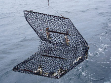 Next,
we attempted to deploy three separate chevron fish traps. (picture
on left) We released the first trap without any problems, but
as the second trap was deployed the line got caught in the winch so
Greg had to cut the line. The divers were sent down to locate the
trap and connect the trap to the buoy. Next, we dropped the third
trap and, then, motored over to the first trap and pulled on board.
Everyone rushed over to see the catch. This trap collected more fish
than usual and a live bottom was inferred. The fish found inside of
the trap were transferred into a holding tank on the aft deck (the
back of the boat).When we opened the trap, Marion and Athan (Dr. Sedberry's
assistants), sorted the fish. Large abundances of black seabass (~75%)
were found, along with scup (~10%), pinfish (~10%), tomtate (~5%),
and spottail pinfish (~5%).
Next,
we attempted to deploy three separate chevron fish traps. (picture
on left) We released the first trap without any problems, but
as the second trap was deployed the line got caught in the winch so
Greg had to cut the line. The divers were sent down to locate the
trap and connect the trap to the buoy. Next, we dropped the third
trap and, then, motored over to the first trap and pulled on board.
Everyone rushed over to see the catch. This trap collected more fish
than usual and a live bottom was inferred. The fish found inside of
the trap were transferred into a holding tank on the aft deck (the
back of the boat).When we opened the trap, Marion and Athan (Dr. Sedberry's
assistants), sorted the fish. Large abundances of black seabass (~75%)
were found, along with scup (~10%), pinfish (~10%), tomtate (~5%),
and spottail pinfish (~5%).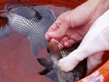 As
fish surface, the air that was once compressed in their bladders expands,
so immediately, Athan and Marion worked to remove excess air from
the fishes. They used a sharp needle to poke through the fish's scales
and into the bladder where the air was stored. (picture
on right) If air is not removed from the bladder, the fish
would be unable to swim down into the water column once they are released
and will float to the water's surface and die. After the air was removed,
the fish were counted, weighed, measured, and released.
As
fish surface, the air that was once compressed in their bladders expands,
so immediately, Athan and Marion worked to remove excess air from
the fishes. They used a sharp needle to poke through the fish's scales
and into the bladder where the air was stored. (picture
on right) If air is not removed from the bladder, the fish
would be unable to swim down into the water column once they are released
and will float to the water's surface and die. After the air was removed,
the fish were counted, weighed, measured, and released. On
a different note, we collected some of the coolest, yet strangest,
fish that I have ever seen; these fish are called Shark Suckers. (picture
on right) From a distance they look like small sharks but upon
closer glance, one realizes that it is not a shark; it is Shark Sucker
(a bony fish). They are extremely odd looking fish that have a large
oval-shaped sucker on the top of their head. Glenn, the ROV operator,
called them opportunistic fish because they attach themselves to sharks
with their big suction cup as a means of getting food. The Shark Sucker
eats the shark's leftovers so they do not have to find their own food
all of the time.
On
a different note, we collected some of the coolest, yet strangest,
fish that I have ever seen; these fish are called Shark Suckers. (picture
on right) From a distance they look like small sharks but upon
closer glance, one realizes that it is not a shark; it is Shark Sucker
(a bony fish). They are extremely odd looking fish that have a large
oval-shaped sucker on the top of their head. Glenn, the ROV operator,
called them opportunistic fish because they attach themselves to sharks
with their big suction cup as a means of getting food. The Shark Sucker
eats the shark's leftovers so they do not have to find their own food
all of the time.