 |
|||
 |
|||
| Renourishment
History of Folly Beach County Park The park commission paid $330, for the land at the west end of Folly Beach in 1981. Structures were built, as well as parking for 400 cars. In 1993, a beach wide renourishment project for all of Folly Island was begun. Folly Island, along with its neighbor to the north, Morris Island had been undergoing erosion for decades. This erosion is believed to be caused by the Charleston Harbour Jetties which block the longshore drift of sediment from northern costal areas and river deltas. The 1993 project called for the placement of about 1.9 million cubic meters of sand over 8,600 meters of shoreline. The project was completed on April 29, 1993, at a cost of nearly $ 8.9 million. Soon after the completion of the renourishment the county park area began to experience severe erosion. |
|||
|
|
|||
 (click on image for higher resolution) |
|||
|
|
|||
| County
Park Renourishment of 1998 The severe erosion at the park was linked to the Army Corps of Engineers 1993 renourishment project. Dredging sand from the Folly River and Stono Inlet upset the natural balance and sand from the park began to fill in the vacancies left by the dredging. In April 1998 the federal government spent $315,000 to renourish the park's beach with 90,000 cubic yards of sand. The rerason the federal government paid for the county park's renourishment was because it was determined that the parks erosion was caused by the Army Corps of Engineer's 1993 project. |
|||
|
|
|||
 (click on image for higher resolution) |
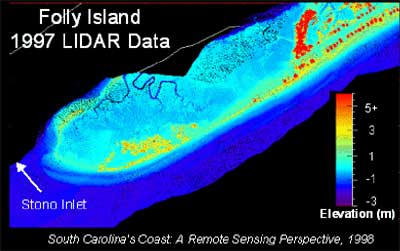
The image on the right is a sample of LIDAR (Light Detection and Ranging) data for the area including Folly Beach county park. This new technique is begining to replace the traditional surveying methods discussed in the coastal processes section. For more information on how this data is gathered, click here. | ||
|
|
|||
| County
Park Renourishment of 1999 By early 1999, sand from the 1998 renourishment was gone and the park was continuing to erode. Only 130 of the original 400 parking spaces are left. To remedy the situation, 49,000 cubic yards of sand was dredged from the Folly River - enough for a 150 foot wide beach 1000ft long. The $228,000 project was again paid for by the Army Corps of Engineers. |
|||
|
|
|||
| Folly County
Park Erosion Image Bank Since 1997, Dr. Leslie Sautter, a marine geology professor at the College of Charleston has been collecting photographic data dealing with the erosion of the Folly Beach County Park. The images, made available by Dr. Sautter, can be used in the classroom as a way to help students visualize the severity of the erosion process. These images are also an excellent preview for a fieldtrip to the beach. Click the camera to view the image bank |
|||
|
|
|||
| The Dynamic
Beach Betsy Sheffield's beach profiling activity that produces accurate results without expensive equipment. Download It ! The activity is available in Adobe Acrobat Reader (.pdf) fromat. |
|||
 |
|||