Go To: Beam Team 2013
Multibeam Analysis of the De Soto Valley Formation in the Gulf
of Mexico
Neah Baechler, Matt Christie, and Dr. Leslie Sautter
Abstract:
The De Soto Valley is located in the northeast portion of the Gulf
of Mexico, approximately 100 km offshore of Pensacola, Florida. This
S-shaped, submarine canyon exhibits many interesting features including
a gentle slope, erosional and depositional features, as well as nearby
salt diapirs. Although the area has been studied since the 1960s,
the most recent mapping expedition was conducted in 2012 by The NOAA
Ship Okeanos Explorer, with a Kongsberg EM302 multibeam sonar system.
Using CARIS HIPS and SIPS 7.1 for post-processing of bathymetric and
backscatter data, suspected hydrocarbon deposits regarding the evident
diapirs were examined. The research will allow further exploration
of the morphology and sediment characteristics in the De Soto Valley,
benefiting both the economy, ecology and geological understanding
of the region.
An Exploration into Crustal Subsidence Recorded on
the San Juan Seamount
Robin L. Banner and Dr. Leslie R. Sautter
Abstract:
The San Juan Seamount lies off the coast of Southern California with
its shallowest depth at 560 m. The volcanic seamount exhibits rough
ridges trending northeast-southwest. The majority of California Borderland
seamounts are smooth and sediment covered, whereas the San Juan Seamount
is one of the few to exhibit weathered grooves and worn rocks. Several
ROV Tiburon dives by Monterey Bay Aquarium Research Institute researchers
in 2003 and 2004 explored the seamount and collected 102 rock samples.
Those dives revealed numerous sub-aerial features such as coastal cliffs
and cobble beaches. A12 kHz multibeam sonar also surveyed the seamount
and detected a slight break in the seamount's slope at a depth of 700
m, suggesting that the San Juan Seamount was an island before it subsided
by between 550 and 700 m, likely since the Late Miocene. In 2011, the
NOAA Ship Okeanos Explorer conducted a survey of the seamount and adjacent
abyssal region using a Kongsberg EM302 multibeam sonar. These data have
been processed using CARIS HIPS & SIPS 7.1 to produce a CUBE BASE
Surface and backscatter mosaic to reveal new insights into past crustal
subsidence. Distinct discontinuities in seabed gradient and the extent
of gravel have been identified.
Geomorphologic Analysis of Baltimore and Wilmington
Canyons on the United States Mid-Atlantic Slope
Samantha M. Bruce and Dr. Leslie R. Sautter
Abstract:
Wilmington and Baltimore Canyons, located 140 km south-east of Delaware
Bay along the U.S. Mid-Atlantic Slope, were explored in 2011 and 2012
by the NOAA Ships Okeanos Explorer and Nancy Foster. A Kongsberg EM302
(Okeanos Explorer, 2011 and 2012) multibeam echosounder was used to
survey the region, and a Kongsberg EM1002 (Nancy Foster, 2011) was used
to survey the Baltimore Canyon area. CARIS HIPS 7.1 software was used
to process and analyze the sonar data and depict the bathymetry of the
area. Slumps and evidence of turbidity flows within the submarine canyons
were documented, and the region's geomorphology was characterized to
inform marine spatial planning efforts specifically related to the management
of deep water corals and demersal fish that inhabit rocky substrates.
Bathymetric analysis of the northwestern Channel Islands
Slope
Angela M. Dapremont and Leslie R. Sautter
Abstract:
The Channel Islands are a series of land masses situated between the
Patton Escarpment and the coast of southern California. Five of the
eight islands make up the Channel Islands National Park which spans
fewer than 400 square miles. All of the islands are considered to be
located in a region known as the California Borderlands. This broader
area is a continental slope that is separated from the continental shelf
by the islands. The Borderlands area is known to be seismically active,
with numerous offshore faults, as well as basins and ridges that trend
in a northwest-southeast direction. The islands themselves contain varying
topographic and geologic features including steep mountains and marine
terraces, and several are prone to landslides, as well as coastal erosion.
Bathymetric data were obtained in 2011 from the NOAA Ship Okeanos Explorer with a Kongsberg EM302 multibeam echosounder, and processed using CARIS
HIPS and SIPS 7.1 software. This bathymetric investigation focused on
the northwest geographic region of the Channel Islands in order to provide
a more accurate characterization of specific features present. BASE
surface generation (depth range of 200 to 2000 m) revealed the presence
of old and young features, as well as slumping and material transport
pathways.
Geomorphic Analysis of the Galapagos Spreading Center
Willie Edwards and Dr. Leslie Sautter
Abstract:
Multibeam sonar data of the Galapagos Spreading Center were obtained
by the Scripps Institution of Oceanography in 2010 from aboard the R/V
Melville. Surveys were conducted using a Kongsberg EM122 and processed
using the CARIS HIPS & SIPS 7.1.2 software. The Galapagos Islands
sit over the Galapagos hotspot, a complicated geologic setting close
to the boundary between the Cocos and Nazca Plates. The Galapagos Spreading
Center is located just north of the island cluster. Bathymetry and morphology
of the spreading center were observed and analyzed in an attempt to
understand and characterize the region's geomorphological history. Research
associated with this area will be beneficial to the understanding of
hot spots and related seafloor tectonic features and deep sea volcanism,
as well as being potentially useful for benthic habitat characterization.
Bathymetric Analysis of Continental Shelf-Edge Marine
Habitat off the Coast of Charleston, SC
Kyle W. Ford, M. Montgomery Taylor, Leslie R. Sautter, and Scott Harris
Abstract:
A delta-like feature was identified at the continental shelf edge, 85
km southeast of Charleston, SC and named the Geneva Delta. This feature
may once have been an active river delta during a lower stand of sea
level approximately 30 meters below present day. Bathymetric data were
collected by College of Charleston BEAMS Program students during a research
cruise in May 2012 aboard the NOAA Ship Nancy Foster using a Reson 7125
multibeam system. The survey area ranges in water depths from 40 to
70 meters. Three-dimensional imagery and cross-sectional profiles were
generated using CARIS HIPS and SIPS 7.1. Analysis of these images revealed
areas of low relief interspersed with rocky outcrops. Additionally,
a variety of fish and marine invertebrates was observed, including the
invasive species, Pterios volitans, commonly known as the lionfish.
The morphological features identified indicate habitats that are of
particular interest to the commercial fishing industry. These data are
crucial to understanding essential fish habitats on the southeast continental
margin in order to determine potential locations for establishing Marine
Protected Areas.
Geomorphologic Impact on the Climate Record of Santa
Cruz Basin, CA
Christina Hefron, Tyler Wheelus, and Dr. Leslie R. Sautter
Abstract:
Part of the California Borderlands, the Santa Cruz Basin is located
off the southern California coast approximately 87 km west of Los Angeles.
The basin reaches a depth of 1957 m and covers an area approximately
1735 km², trending northwest to southeast. Similar to the anoxic Santa
Barbara Basin, the Santa Cruz Basin contains varves with a foraminiferal
climate record dating to the Miocene. During March 2011 the NOAA Ship
Okeanos Explorer collected multibeam sonar data of the basin using a
Kongsberg EM302 multibeam sonar system. CARIS HIPS 7.1 software was
used to create a high-resolution CUBE BASE bathymetric surface and three
dimensional map of the basin's geomorphology, which revealed slumps
and turbidity flows from the nearby Santa Cruz Canyon. The drainage
system, canyon turbidity flows, and slumping have potentially disturbed
the climate record along the edge of the basin floor. As with nearby
basins, the right-lateral movement caused by transform faults of this
region may be responsible for the slumping along the western rim of
the Santa Cruz Basin. Along the eastern rim of the basin, a dendritic
drainage system was identified as an outlet for the Pilgrim Banks which
divides the Santa Cruz Basin from neighboring Santa Monica Basin.
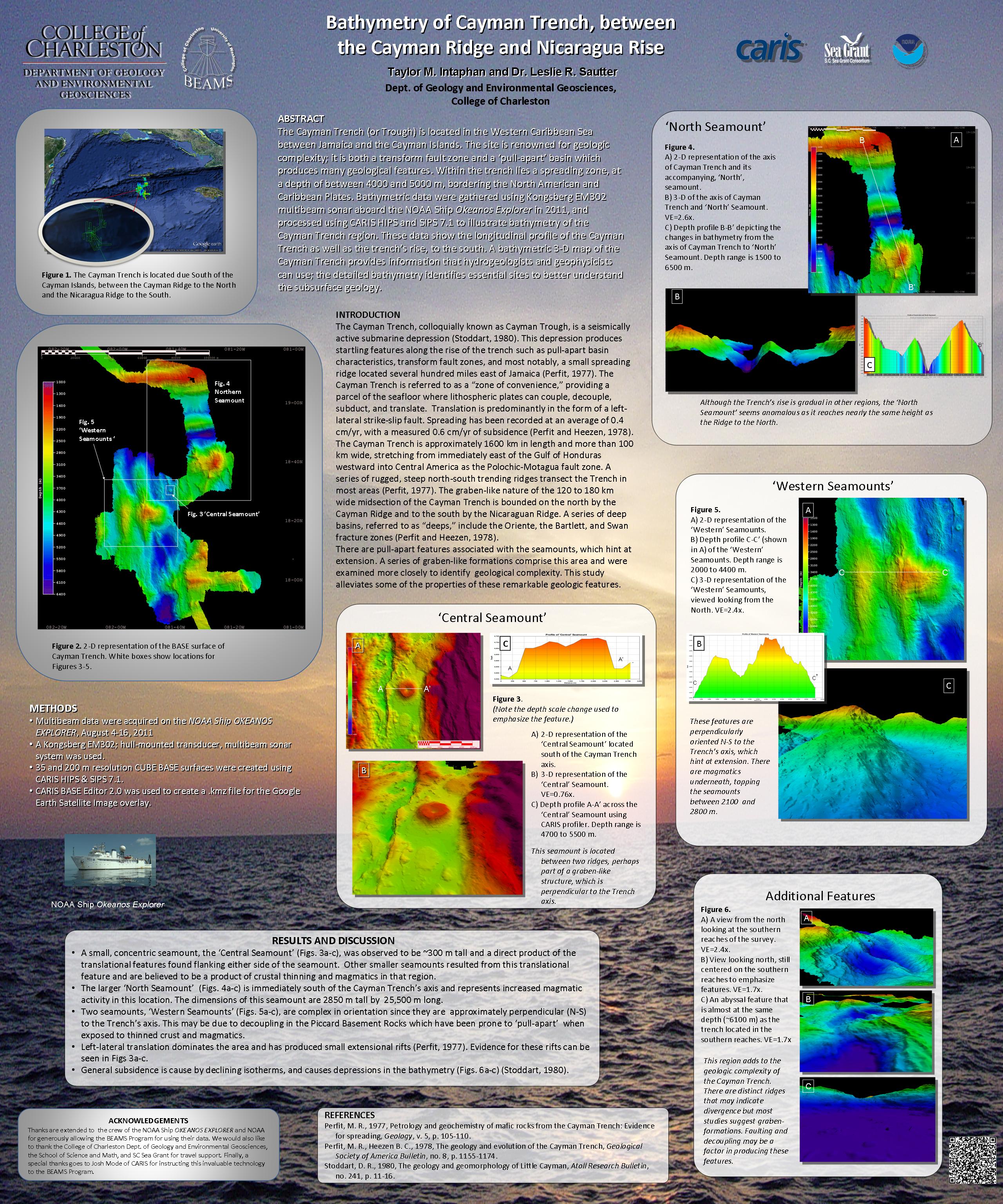
Bathymetry of Cayman Trench, between the Cayman Ridge
and Nicaragua Rise
Taylor M. Intaphan and Dr. Leslie R. Sautter
Abstract:
The Cayman Trench (or Trough) is located in the Western Caribbean Sea
between Jamaica and the Cayman Islands. The site is renowned for geologic
complexity; it is both a transform fault zone and a 'pull-apart' basin
which produces many geological features. Within the trench lies a spreading
zone, at a depth of between 4000 and 5000 m, bordering the North American
and Caribbean Plates. Bathymetric data were gathered using Kongsberg
EM302 multibeam sonar aboard the NOAA Ship Okeanos Explorer in 2011,
and processed using CARIS HIPS and SIPS 7.1 to illustrate bathymetry
of the Cayman Trench region. These data show the longitudinal profile
of the Cayman Trench as well as the trench's rise, to the south. A bathymetric
3-D map of the Cayman Trench provides information that hydrogeologists
and geophysicists can use; the detailed bathymetry identifies essential
sites to better understand the subsurface geology.
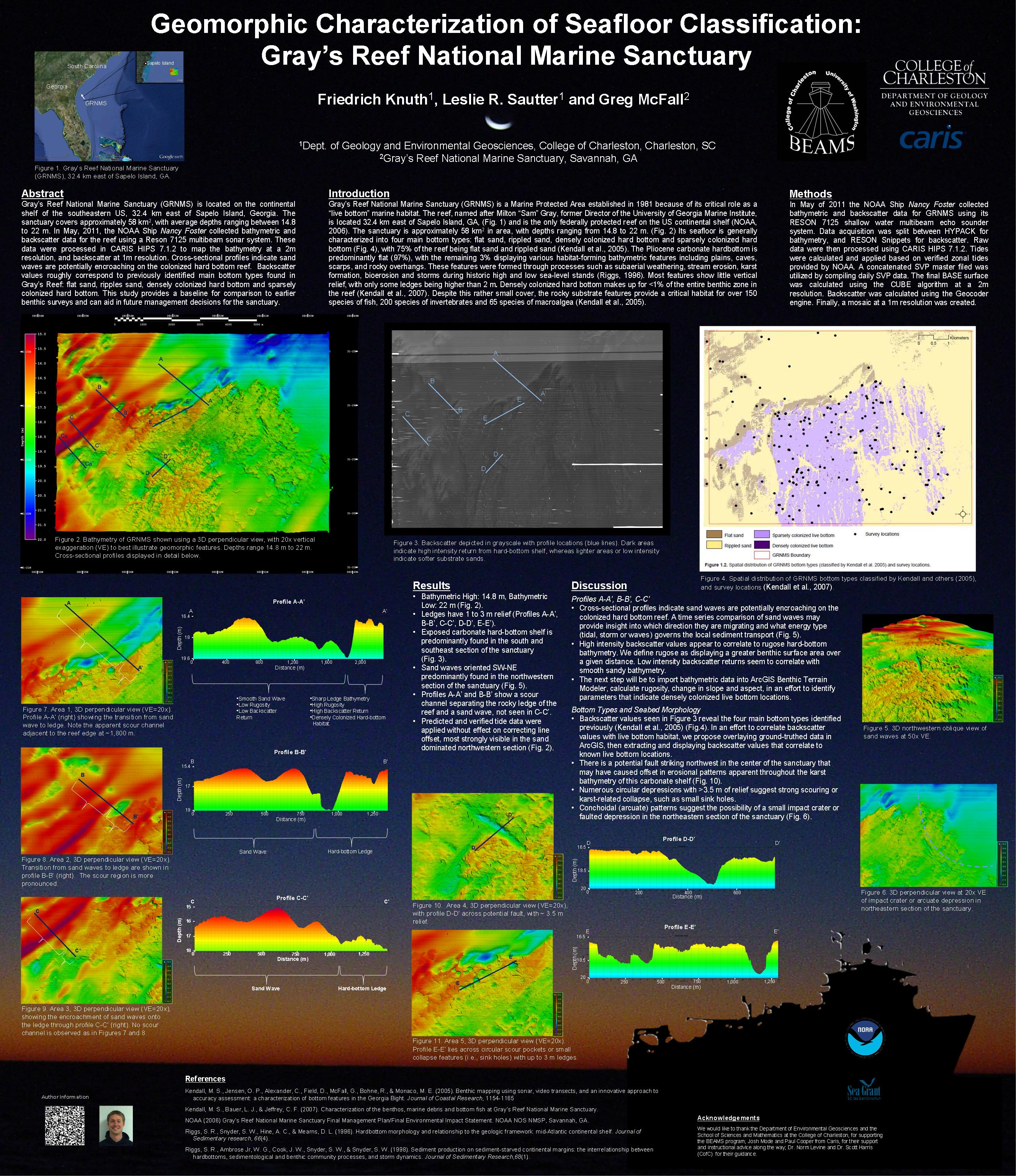
Geomorphic Characterization of Seafloor Classification: Gray's Reef
National Marine Sanctuary
Friedrich Knuth, Leslie R. Sautter and Greg McFall
Abstract:
Gray's Reef National Marine Sanctuary (GRNMS) is located on the continental
shelf of the southeastern US, 32.4 km east of Sapelo Island, Georgia.
The sanctuary covers approximately 58 km², with average depths ranging
between 14.8 to 22 m. In May, 2011, the NOAA Ship Nancy Foster collected
bathymetric and backscatter data for the reef using a Reson 7125 multibeam
sonar system. These data were processed in CARIS HIPS 7.1.2 to map the
bathymetry at a 2m resolution, and backscatter at 1m resolution. Cross-sectional
profiles indicate sand waves are potentially encroaching on the colonized
hard bottom reef. Backscatter values roughly correspond to previously
identified main bottom types found in Gray's Reef: flat sand, ripples
sand, densely colonized hard bottom and sparsely colonized hard bottom.
This study provides a baseline for comparison to earlier benthic surveys
and can aid in future management decisions for the sanctuary.
Bathymetric Analysis of the Southern Portion of the
Mid-Atlantic U.S. Continental Margin
Per W. Lorentzen, Samir Younes, and Dr. Leslie Sautter
Abstract:
Multibeam sonar data were collected by the NOAA Ships Okeanos Explorer (June, 2011 and November, 2012) and Nancy Foster (June, 2011) during
three cruises to acquire high-resolution bathymetric and backscatter
data of the continental slope due-east of the northern portion of the
Outer Banks, North Carolina and southern Delaware coastlines. Kongsberg
EM302 multibeam sonar was used, and bathymetric and backscatter data
were processed using CARIS HIPS & SIPS 7.1 software. Surveys were
run parallel to the shelf edge, ranging in depth from 100 to 3000 m.
This area has some of the steepest gradients of the United States east
coast. The shelf is well incised by many medium-sized submarine canyons
in close proximity of each other as well as the large Norfolk and Washington
Canyons that characterize the slope and rise. High-resolution bathymetry
can help with predicting areas where tsunamis may occur as a result
of major sediment slumping. The continental rise is seldom the focus
of mapping projects, but within our data are three examples of sediment
travelling from shelf to rise.
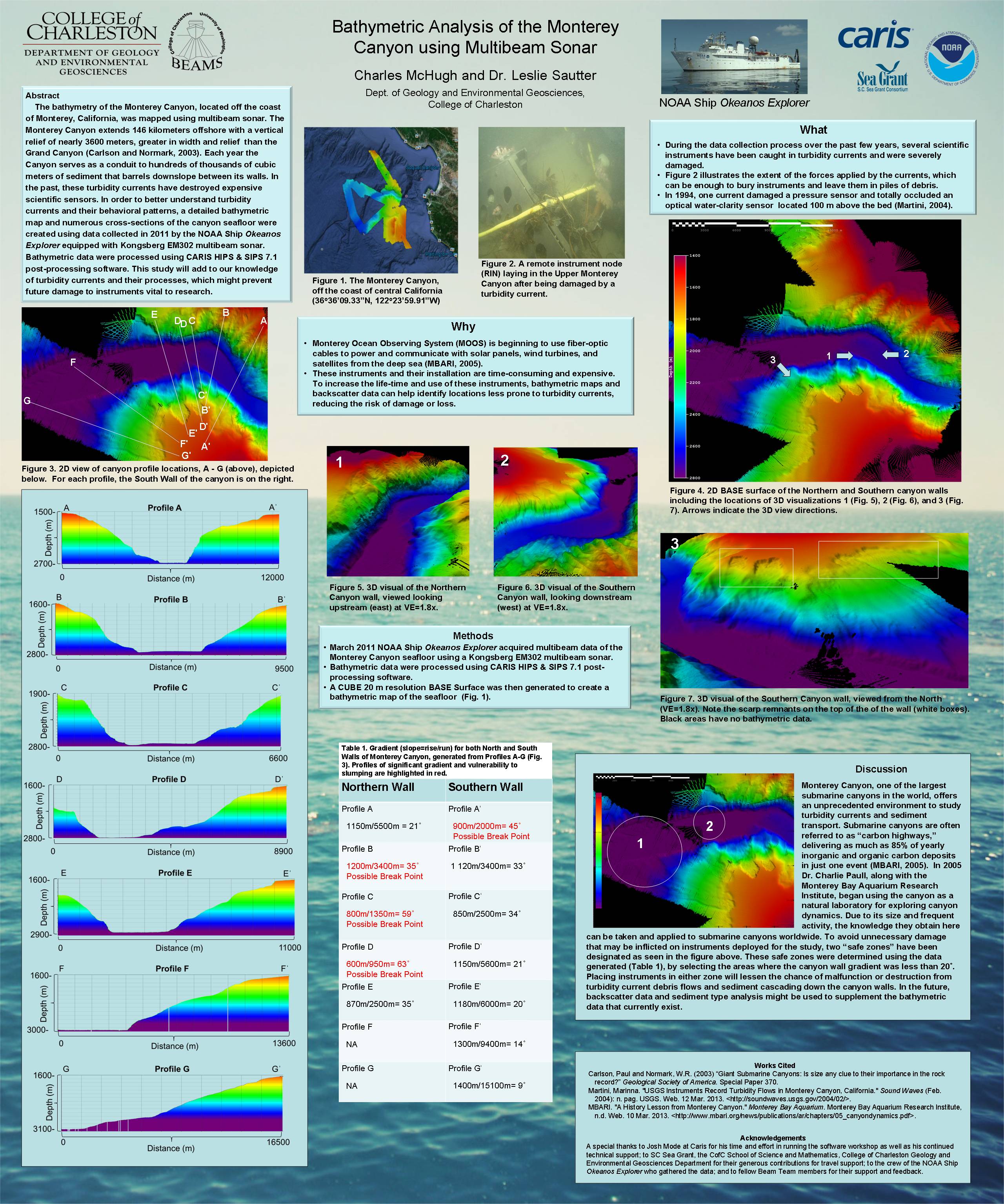
Bathymetric Analysis of the Monterey Canyon using Multibeam
Sonar
Charles McHugh and Dr. Leslie Sautter
Abstract:
The bathymetry of the Monterey Canyon, located off the coast of Monterey,
California, was mapped using multibeam sonar. The Monterey Canyon extends
146 kilometers offshore with a vertical relief of nearly 3600 meters,
greater in width and relief than the Grand Canyon. Each year the Canyon serves as a conduit to hundreds of thousands
of cubic meters of sediment that barrels downslope between its walls.
In the past, these turbidity currents have destroyed expensive scientific
sensors. In order to better understand turbidity currents and their
behavioral patterns, a detailed bathymetric map and numerous cross-sections
of the canyon seafloor were created using data collected in 2011 by
the NOAA Ship Okeanos Explorer equipped with Kongsberg EM302 multibeam
sonar. Bathymetric data were processed using CARIS HIPS & SIPS 7.1
post-processing software. This study will add to our knowledge of turbidity
currents and their processes, which might prevent future damage to instruments
vital to research.
Bathymetric Study of Four Submarine Canyons on the
Southern Edge of Georges Bank
Savannah Norvell, and Dr. Leslie R. Sautter
Abstract:
Georges Bank is a large submerged plateau, encompassing an area of 42,000
m² on the northeastern continental shelf. On its seaward boundary
it is incised by several submarine canyons, which play a significant
role in the high levels of productivity that have historically characterized
the area. Marine organisms thrive in submarine canyons, and recent approaches
to protect fish populations have emphasized the importance of these
benthic habitats. Raw bathymetric data were acquired with a Kongsberg
EM302 multibeam sonar system from aboard the NOAA Ship Okeanos Explorer in 2012 during a five-leg survey of the U.S. Atlantic Margin. Four of
the submarine canyons surveyed have been processed and analyzed in this
study with the CARIS HIPS 7.1 software: Hydrographer Canyon, Oceanographer
Canyon, Gilbert Canyon, and Lydonia Canyon. These data have been used
to predict coral habitats on the basis of canyon depth, relief of canyon
walls, and location of hard substrate. Gaining a clearer insight about
the continental shelf and slope morphology of the Georges Bank area
will aid in ecosystem management.
Bathymetric and Morphologic Analysis of the Mississippi
Slope
Harris Pantlik, Matthew Hughes, and Dr. Leslie Sautter
Abstract:
Multibeam sonar and backscatter data were collected in August, 2011
aboard the NOAA Ship Okeanos Explorer along the Mississippi continental
slope, 70 km southeast of the Mississippi River Delta. Data were collected
using a Kongsberg EM302 and were processed with CARIS HIPS 7.1. This
region has been heavily investigated by the petroleum industry and academia
due to its archetype marine petroleum-bearing basin. Bathymetric data
yielded high resolution images of several geomorphologic features, including
wave-cut terraces, salt diapirs, large scale slumps, gas vents, sediment
fan lobes and other structures formed during the Late Pliocene. Evidence
of salt piercement was found on the Biloxi Dome while a large slumping
mass can be identified on the southern margin of the Mitchell Dome.
The southern margins of several other domes exhibit small amounts of
slumping.
Predictive habitat modeling of a submarine ridge off
of the West Florida Escarpment
Matthew Rittinghouse; Dr. Leslie R. Sautter; Dr. Peter J. Etnoyer
Abstract:
Habitat modeling offers a useful tool for deep-sea exploration planning
and a cost-effective approach to deep-sea ecosystem management. Challenges
to these techniques include the appropriate scale of analysis, availability
of data, definition of predictor variables, and potential for model
verification. In August 2012, the R/V Falkor collected high resolution
bathymetry data along the West Florida Escarpment, using Kongsberg EM710
and EM302 multibeam echosounders. A ridge feature near the shelf break
(400-650 m depth) had been previously mapped by the NOAA Ship Okeanos
Explorer in April 2012.Video transects conducted by the Global Explorer
MK3 ROV revealed a diverse assemblage of deep-sea corals and associated
organisms. Habitat forming corals, such as Lophelia pertusa, Leiopathes sp., Plumarella sp., and Stylaster sp., were observed.
The goal of this work is to use CARIS HIPS 7.1, BASE Editor 4.0, and
ArcGIS 10.1 to generate a mesoscale predictive habitat model based on
observed species distributions, substrate character, and bathymetry.
This predictive model will be used to assess the areas with greatest
potential for conservation and future research.
|
